It's been way too long since a backroads post. Now, as then, my route is anything but a back road to the locals, and I apologize for any offense they might take (and remind them that I am avoiding telling the general public about the really good backroads). It covers a fair stretch of Route 2, only a backroad compared to I-90, but to get right down to it, 90 probably does have 100 cars to every 1 on 2.
But let me back up a sec. Route 2 was the third leg of this trip. The joints of these legs: curving grades making their -scents (de- or a-) as the westward course confronted coulees and a river. Between the joints, longbones straight and narrow; straighter than the crow flies, lies the engineer's centerline. The surveyor runs due south, mile after mile, and Route 17 is born; turning 90 degrees west, he draws Route 2 to Waterville. Up north, Route 174 does bend a bit more, flexing to the landscape and paths discovered by creatures and the people that hunted them ever since the end of the Ice Age.
Taking off out of Grand Coulee on 174 begins with a climb, and you cross under one of the primary electric umbilicals of the Power Grid. The towers march off on their line, and174 takes off through some pretty country, especially late on a warm Spring day.
 |
| Coulee climb #1: Outta Grand Coulee (or is that Coulee City?) |
There's the mildest switchback ever ascending to the next plateau, and then straightest of shots beyond. The road only makes sense if your concept of land is a grid. Until the last century, everyone traveled up and down the coulee (you know, where there's food and water), and you can still do it on RT 155, but once the land is cut into sections and quarters, and you need to get grain to market, a road straight through the fields makes sense. It's modern agriculture's umbilicus to markets for petrochemicals in and food out, laid down on the Cartesian Grid.
 |
| Tanks (for fuel? fertilizer?) and Elevators (for output) on Route 2. |
Monotonously straight as much of this route may be, there are a few breaks that take my breath away. Like entering Moses Coulee.
Looking across the sage at golden cliff walls with cocoa talus skirts, I am in love with this place every time I see it. Luckily (and with some attention to timing), I have been through here many times in the fading afternoon, and every time, it is a blessing.
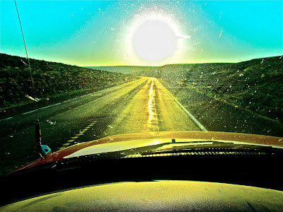
This last trip, on that big coulee-climb up from Moses, I shot out onto the top and into a straightaway pointing right into the setting sun. Beautiful, too, but also difficult driving. Glare in the face, windshield lit with dozens of bugsplats, each a tiny firework of captured sun in my eyes, scratch refractions, a haze of dust alight across it all, shiny tarlines on the road reflecting even more sun from the ground up.
Luckily, there was nearly no traffic, and what little there is is visible from miles away. Because I guess even Route 2, mightiest of the 174-->17-->2 run, is a backroad in the interstate age. Lonely straightaways where driving is as simple as it gets and you can take in the country, which is flat and clear enough that it passes at a stately pace, not much in the foreground to whip by in a blur. I'm pretty sure I was out of cell range for most of the trip, which also felt good, getting off the Communications Grid (even if I was confined to the road engineer's east-west north-south orientation).


No comments:
Post a Comment